Ocean Properties
Southern Africa is bounded by the South Atlantic Ocean on the west coast and the Indian Ocean on the east coast. These two prominent bodies of water, combined with the Southern Ocean further south, influence our local and global climate regimes, carry more than 90% of all our imports and exports; are major food sources, impact on our coasts, beaches and shipping, provide numerous recreational opportunities and are a natural environment rich in species and diversity.
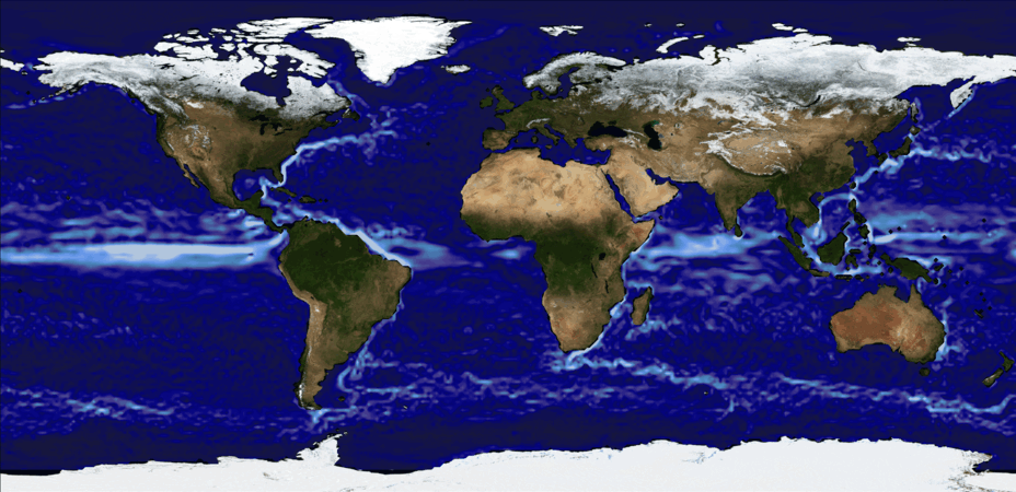
Currents
Ocean currents are continuous and predictable flows of water which move in particular directions. Water in the oceans move vertically and horizontally. The vertical movements are reffered to as upwelling or downwelling, whereas, the horizontal movements are called currents. Wind, gravity and density are the three main factors that drive ocean currents. These factors allow us to separate ocean currents into two major systems – wind-driven circulation and the thermohaline circulation. The thermohaline circulation, often reffered to as the “global coveyor belt”, is a slow moving system with typical speeds of 1 cm/s (slower than the speed at which an ant moves).
This system is driven by horizontal and vertical differences in temperature and salinity which is where the name comes from: thermo (heat) and haline (salt). The thermohaline circulation slowly replaces seawater at depth with water from the surface and slowly replaces surface water elsewhere with water rising from depth. These processes are extremely slow – with water taking 100’s or 1000’s of years to cross a ocean basins.
Wind-driven currents are found at the surface – where the wind and ocean surface meet. These currents are much faster than the thermohaline circulation, reaching speeds of 2 m/s (about as fast as you can walk). Just like the name suggests, the winds drive the water at the surface and they are deflected in specific directions depending on the hemisphere by the Coriolis effect. The interaction of the wind with the ocean surface mixed with the Coriolis force results in the formation of anticyclonic ocean gyres which have a clockwise circulation in the Northern Hemisphere and an anticlockwise circulation in the Southern Hemisphere.
Temperature
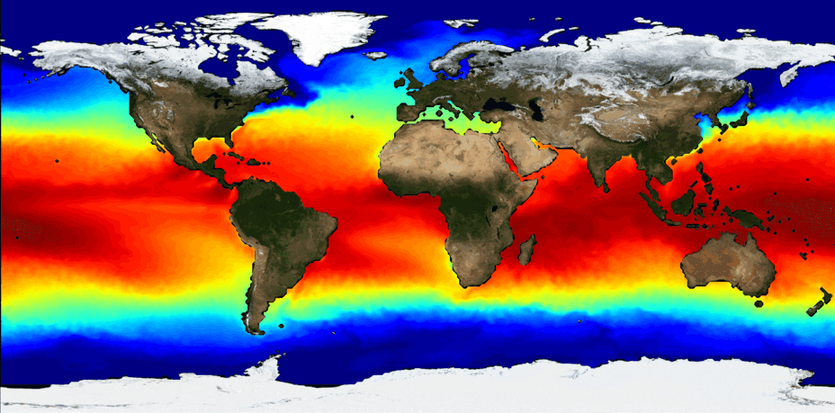
Virtually all the ocean heat comes from the sun and a minute amount comes from the earth’s interior through gas vents at the ocean bottom. Because the equatorial areas are more faced toward the sun, the amount of heat absorbed per unit area is larger than at the poles. This causes the temperature to be higher at the equator than at the poles. The area of higher temperature shifts southward and northward with the change in seasons. Note how the warm water off the east coast of southern Africa in summer penetrates southward, while off the west coast colder water bulges northward. This causes significant temperature differences between the east and west coasts.
So now that you know how temperature varies with latitude, how does it change vertically? Well, given that the dominant heat input from the sun takes place at the ocean’s surface, the surface layers of the ocean are the warmest. As you move lower down the water column, the temperature decreases. This is especially the case in the equatorial and temperate latitudes, while in the polar regions the heat input at the surface is low, so that there is not a large change in temperature with depth. The minimum temperature (at the sea bottom) is between -1 and -2 °C. You may be wondering, shouldn’t sea water freeze at such temperatures? Well, yes it should and so it does at the surface but the higher pressure at depths stop this from happening. Typical temperature profiles show that the decrease in temperature with depth is not linear, but that the temperature undergoes a significant “jump” at a depth of a few hundred meters. This sharp decline is known as the thermocline. Between the surface and the start of the thermocline the water is very isothermal (very much the same). This is referred to as the mixed layer, where the surface waves continuously churn the water. The higher the wind speed, the larger the waves, the deeper the mixed layer. In summer, the surface temperature is higher, and the mixed layer shallower. While in winter, the surface temperature is lower, and the mixed layer deeper because of the increased occurance of storms.
Salinity
The salt in the oceans is the result of millions of years of minerals leached and dissolved from the solid earth. A large portion of this salt comes from rivers, in addition to a quantity dissolved from rocks and sediments below the ocean floor, through volcanic vents. The weather also plays a role on a smaller scale, as the rain deposits mineral particles into the oceans. Heat from the sun vaporizes almost pure water from the surface of the sea, leaving the salts and minerals behind. The vaporized water returns to the ocean via rivers or precipitation, to wash down more salt, which becomes ever more concentrated. This process is part of the continual exchange of water between the land, ocean and the atmosphere that is called the hydrological or water cycle.
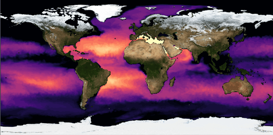
Rain water, or precipitation, is slightly acidic due to dissolved compounds. When this acidic water beats down on the land and rocks, they end up dissolving the minerals in the rocks and return them to the water. Sodium chloride (table salt) represents more than 80% of the “saltiness” in the sea. The salt(s) then flow down rivers and streams to their final destination in the oceans, where they remain. Over the course of millions of years, this salt has accumulated to be a distinct characteristic of the oceans. The salinity of sea water is usually 35 ‰ and is primarily made up of these salt ions listed in order of decreasing concentrations: Chloride, Sodium, Sulfate, Magnesium, Calcium, Potassium, Bicarbonate, Bromide, Borate, Stontium and Flouride. Amazingly, their proportions are always the same which is explained by the fact that salinity differences are caused by either evaporating fresh water or fresh water injections from rivers, with freezing and thawing also playing a role. The animated world map shows how the salinity of the oceans changes slightly from around 32 to 40 ‰. Low salinity is found in cold oceans, particularly during the summer season when ice melts., while high salinity is found in subtropical regions where evaporation is high and precipitation low. You may be wondering why the highest salinity is not found at the equator. While the equatorial region receives the highest incoming solar radiation, it also experiences high levels of precipitation.
Oxygen
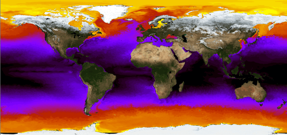
It should be remembered that oxygen is a natural element forming water together with hydrogen. However, the “oxygen in sea water” is actually oxygen dissolved from the atmosphere through vigorous stirring and turbulence cause by wind and waves, and through precipitation. The equatorial and mid-latitude regions of the earth have a lower oxygen content at the surface than the high-latitude regions.
Chlorophyll
Add text
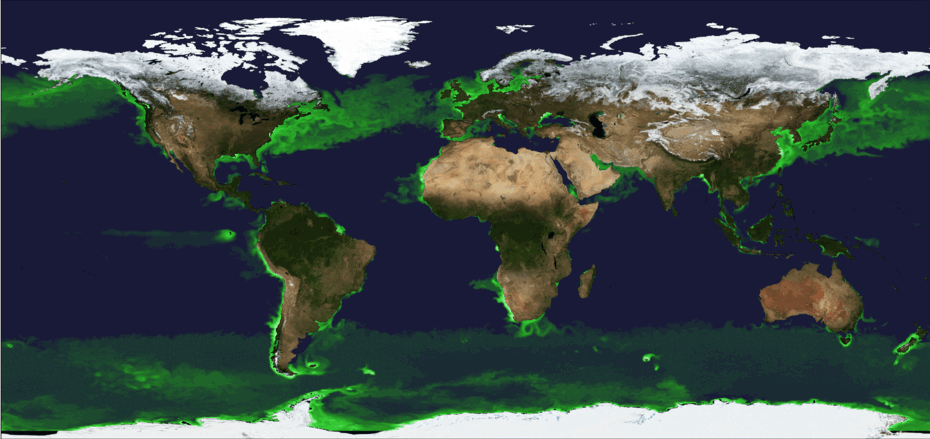
add text
Waves
When the wind blows across the ocean surface, it creates small capillary waves (typical size about 1 mm). As the wind continues, or becomes stronger, the waves grow in height, wave length and period. If the wind has blown at a certain speed over a sufficiently large area for a long time, the wave field becomes “fully developed” (the waves do not change their characteristics any more). In a fully developed wave field there are waves of all sizes, but there is a wave height/period where the energy is largest. Once the wind stops, the small, short-period waves disappear and the remaining (smoother) wave is called swell.
Swell typically has a period of about 8-15 seconds and a height of about 1 m or more. Waves are normally very irregular (not as smooth as indicated in the figure below) but have crests and troughs. The horizontal distance between two crests is the wavelength, and the vertical distance between a crest and a trough is the wave height. The time it takes two successive peaks to pass an observer is called the wave period. As the swell approaches the shore, the shallower bottom topography causes the swell to become larger, reaching a point where it can no longer support itself, and breaks. This is the point at which white foam is visible on the edge of the wave, and the optimum time to catch a wave!